 |
 |
 |
|
|
|
RSVP for today's climb after the previous week's climb!
| Check out the week 5 flyer (PDF)! |
| The start list is available here! |
| results? | right here! |
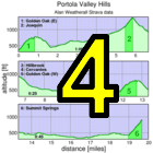
| profile |  |
| distance | 7.67 miles (12.3 km) |
| climbing | 2368 ft (721 meters) |
| grade | 5.86% |
| where? | see below |
| when? | 02 Nov 2013 |
| what time | registration 9:00 to 10:00 climb starts @ 10:10 |
| RSVP | check back later! |
| waiver | Please fill one out before the climb! |
| how? |  |
| how much? | $10 (free for juniors and those with volunteer credit) |
| why? | Ask not why; just do! |
| coordinator |  |
| volunteers | sign up! |
| aerial view | Will Van Kaenel, Google Earth |
| weather | Weather Underground |
| deja-vu? | New! |
| BikeMap | |
Sorry, folks! Our insurance requires all riders wear helmets during the climb, and we follow the USA Cycling rule against ear buds or other head phones. Rock to tunes before the climb, perhaps, but we need riders to pay attention to what's happening during the climb...
We recommend suggesting parking along Alma Bridge Rd. with a warm-up ride around the reservoir. There are parking lots at the dam and at Miller Point picnic area. There may be parking at the Lexington School on Old Santa Cruz Hwy. There is limited parking at Black and Montevina and at the Bear Creek overcrossing at CA17 (on the reservoir side).
There's room for about 5 cars at the bottom of Black Rd.
When you get off 17 and stop at the stop sign, turn right over the overpass, and then right again. There's a dirt area right there that people park in, but I often see them getting tickets so I would not suggest parking there. If you continue on about 1/4 mile there is a large dirt parking area on the left. I have never seen cars there getting ticketed.You can take the los gatos creek trail bike path to Lexington Dam. This can be slower than expected so make sure to allocate plenty of time.
Once you are on the dam, you can go left and take the long way around the reservoir (take a right on Aldercroft Heights and a right on Old Santa Cruz) or you can go towards 17. At 17 you can either ride a singletrack trail or walk against traffic on the shoulder to get to the Bear Creek overpass. If you ride on the shoulder there's a grate that forces a rider into the traffic lane, and where the onramp curves onto the merging lane cars tend to cut the corner which doesn't leave much room for a cyclist, so please walk.
Once you're at Bear Creek, cross the bridge and take a right onto the frontage road where registration and the start will be.
It takes about 30 minutes to ride around the reservoir at a moderate pace. It's rolling hills, about 8 miles and 800 feet of climbing. There's even porta-potties along the way.
You can either
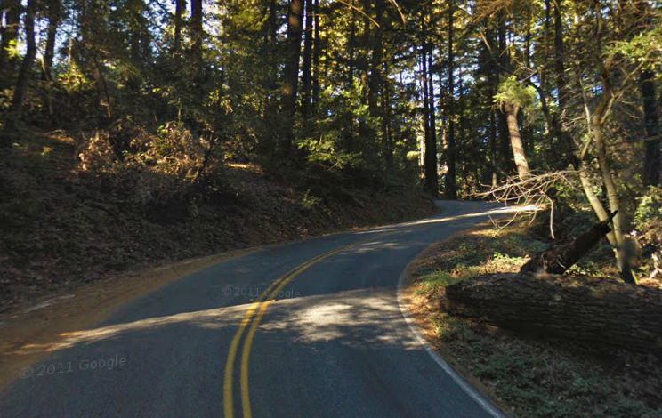
Another way is to ride up 9, then south on 35 to Black, and down Black. Black is steep and twisty and there's a lot of road debris, especially after the winds we have been having, so be careful if you do this.
The other way is to go up Bolhman/On Orbit, then ride through the open space (on dirt, it's about 1 mile) to the top of Montevina, and come down that way. This may be a bit "warmer" of a warm-up than you wanted...
We will post start times before the ride, so stay tuned!
Volunteers make Low-Key tick! Without them, we no longer function. Please sign up for any week in the series using our volunteer form! Thanks!!!
Low-Key is all about a group of friends riding up a hill together. It's like any other informal group ride, except we time you to the top and report the results on our web site. But we have no road closures, no lead vehicle, no follow vehicle. We are traffic, sharing the roads with other traffic, following the laws and courtesy which applies to traffic. Think of it as a human-assisted Strava. We're each responsible for our own actions out there, on and off the bike, both as users of the road as as courteous visitors to the neighborhoods we pass through. "Ceci n'est pas un race".